Unveiling the Impact of the 2022 Fujairah Flood: A Comprehensive Study Using Advanced GIS Technology
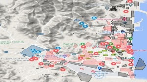
Fujairah, the fifth largest Emirate in the United Arab Emirates (UAE), witnessed one of its most devastating floods in July 2022, a disaster marked by the highest rainfall recorded in the Emirate in over 27 years. This catastrophic event resulted in seven tragic casualties, widespread property damage, and significant destruction of infrastructure, highlighting the urgent need for effective flood management and response strategies.A recent study conducted by researchers from Fujairah Research Centre (FRC) delves deep into the aftermath of this flood, employing cutting-edge Geographic Information System (GIS) technologies such as QGIS, ASPOSE, MyMap, and FloodMaps to develop detailed flood maps and elevation charts. Spanning approximately 1,450 square kilometers, Fujairah is renowned for its rugged mountainous terrain, which significantly influences its climate and weather patterns. The emirate experiences a semi-continental climate, with an average annual rainfall of around 8.33 millimeters. However, the torrential rains of July 2022 far exceeded this norm, with rainfall levels reaching an unprecedented 221.8 millimeters at Fujairah Port and substantial amounts at other locations like Fujairah Airport and Masafi. By integrating high-resolution satellite imagery with various data sources, the FRC researchers developed a detailed visualization of the flood's impact. This effort provides valuable insights into the extent of the damage and serves as a crucial tool for government institutions to formulate more effective flood management strategies.
The study’s data collection was robust, drawing from multiple sources, including the Media Centre of Fujairah Environment Authority (FEA), the Mohammed Bin Rashid Space Center (MBRSC), and various satellite imagery platforms. High-resolution images from Khalifa Sat, part of the Sentinel-1 Satellite, played a pivotal role in identifying and differentiating the affected areas. QGIS, an open-source geographic information system, was utilized to map and analyze the flooded regions. The researchers added polygon features to the satellite images to create detailed flood maps, illustrating the severity of the inundation.The flood mapping process was further refined using tools like Sentinel Hub's EO Browser, which assisted in visualizing rain cloud coverage and filtering relevant data. The researchers converted GeoJSON files to KMZ format using the ASPOSE tool, allowing the data to be visualized on Google MyMaps. This platform enabled the creation of custom layers and annotations, including before-and-after imagery of the affected areas, providing a clearer picture of the flood's impact.One of the key findings of the study was the significant correlation between flood risk and elevation levels. Areas with lower elevations, particularly those close to sea level, were found to be more susceptible to severe flooding. The researchers examined elevation data from 16 places within Fujairah, identifying high-risk zones based on factors such as proximity to the sea, the presence of dams, and the overall topography. For example, Al Shirya, with an average elevation of just 0.6 meters above sea level, was particularly vulnerable, while regions with higher elevations, such as Mudok and Al Hail, experienced medium levels of damage despite their higher altitudes. This indicates that while elevation is a critical factor, other variables, such as the presence of dams and heavy rainfall, also play significant roles in flood risk.The study’s findings underscore the importance of utilizing GIS technologies to assess and manage flood risks. By visualizing flood-prone areas and analyzing elevation data, the study provides crucial information for disaster preparedness and response. The flood maps and elevation charts developed in this research can serve as a valuable tool for government agencies and municipalities, aiding in the planning and implementation of effective flood management strategies.The ability to accurately map and analyze flood risks is essential for improving preparedness and response, ultimately safeguarding lives and resources. As climate change continues to intensify weather events, the insights gained from this study are vital for developing robust strategies to mitigate the impact of future floods. The methodologies and protocols established in this research can be applied not only within the UAE but also in other regions, contributing to a more resilient approach to flood management and disaster response.For more information read the full article by Fatmah Rashed Mohamed Obaid Alhefeiti, Manar Ahmed Mohammed Alblooshi, Reem Y Yaqoub Yousif Ahmed Abdalla, Muhammed Sirajul Huda Kalathingal, Shaher Bano Mirza and Fouad Lamghari Ridouane. “Investigation of the effects of heavy rain and flood in emirates of fujairah- uae and construction and compilation of flood map and elevation chart using state of the art gis technologies”, International Journal of Development Research,12, (09), 58827-58831.
